 Among the woods and green meadows: trekking in the Malenco Valley at the refuge Bosio
filled by Giulia & Romeo

Nestled in the heart of the Valtellina, Sondrio is the center of an area that lies between the Alps and the heart of the Orobie Rhaetian Alps, dominated by the Piz Bernina, the most easterly of the Alpine 4000. The city is a point of reference on maps for many hikes and walks in the surrounding valleys.
In an area dotted with huts, Valmalenco, Galli-Bosio is the first encountered, lying on the side of a valley.
And like all of the most isolated and secluded places gives the most intense emotions.
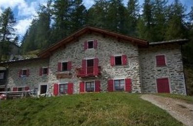
A refuge from the early twentieth century that has kept its atmosphere a little out of time: stone, with red shutters on two floors, surrounded by pine trees Alpe Airale.
(For those who want a taste of the dishes, pizzoccheri, gnocchi, polenta and sausages, cold cuts and cheeses of the valley, remember that the open period is from June 20 to September 25, phone 0342-451655)
The photograph that captures the arrival of the Walker is one of those to be included in the album of walks: at an altitude of 2086 m, on a moraine hill, like a fairy-tale the refuge overlooking a large grassy bank on which are mushrooming huge erratic boulders.
In just three hours walk, coming from Primolo, left behind civilization, the sounds, the colors a bit faded, the life of every day. For a dip in the green, in its various shades, and maybe even one of the pools of crystal water formed by the Torreggio river that flows nearby. With the ability of those close encounters typical of wild places: marmots, deer and chamois.
For those coming down from the Val Masino the impact is not less strong: after walking between the gray stones and rocks, almost naive, this picture is a feast for the eyes.
All around, as a frame, the Horns: those burned and those Airale. And if only we can win the laziness, and before or after the long-awaited stop walking even half an hour, the view extends to Monte Disgrazia, to Cassandra, in the whole of the Bernina group.
A destination in itself rewarding, which often is only one of the stages of two classic routes in the mountains of Valtellina: The Sentiero Roma and the Valmalenco Alta Via.
Going back home would be a shame not to visit the Ethnographic Museum of History of the Church, set in the ancient parish church and the Oratory of San. Carlo.
A history section traces the history of the valley through artifacts, photographs and information panels, religious art that provides visitors with paintings, wooden statues, a precious Way of the Cross, costumes and banners of confraternities; ethnographic sections present the reconstruction of working environments and objects related to various activities of the valley, from the production of butter and cheese to the processing of flax, slate and soapstone.
Itinerary
From the small parking area you are walking along a well maintained dirt road and visible, marked with the traditional flag red white red. Covering it, we head towards the Alps and Lake once the road is blocked by a barrier that allows only the authorized persons, we proceed along the track, entering in a forest of big larch and pine.
Leaving the forest, the trail reaches the wide plateau of the Alpe Lake, elevation 1614 m.
(or can be accessed from almost flat trail with Primolo)
Former mountain lake, Lake now hosts the Alpe small houses and a church.
Passing on the right side, we leave the Alps behind through the meadows.
Entering a forest of conifers on the right and left fork up to Alpe Mastaba, bypassed the steep wooded ridge, arriving to Val Torrèggio.
Leaving the forest and crossing the path that comes from Torre Santa Maria, then you reach the Alps at an altitude of 2097 m Airale, with its small houses, and walking through large boulders you reach a bridge over the Torrèggio River.
After crossing the bridge, recently posed by hunters, going down a few meters, arrive to the Refuge Bosio 2086-Galli. Elegant, stone gray spotted here and there by bright red wooden shutters, the building dates back to 1925.
For those who want to continue, with an hour of walking we reach the lake of Zana, beyond which there is a pasture where they sell cheese in two hours you can reach the lakes Cassandra, beyond the Horns of Airale, and White Stone (2490 m), opposite the Monte Accident and Bernina. You can make the crossings and the Rifugio Alpe Arcoglio Desio.
The refuge Bosio Galli-point support of two classic routes at high altitude: the Sentiero Romano and the Valmalenco Alta Via
Reaching the departure
From Milan: Viale Zara follow for Lecco and take the SS36. Once in Lecco continue to Colico, then on SS38 to Sondrio. After 35 km leave the main road and enter into the center of Sondrio / Valmalenco, follow the signs for Chiesa Valmalenco.
From Chiesa Val Malenco towards Primolo at the first bend take the dirt road that runs in the opposite direction to the ben. Follow it until you reach a bar. (Small parking area)
From Brescia along the Valcamonica up to Edolo, turn left after the bridge on the Oglio go up towards the passo dell'Aprica. Superatolo, continue up to the highway of the Valtellina valley, turn left. Continue to Sondrio, take the ring road until you reach the following exit.
Difference in altitude from 1000 m Chiesa Valmalenco
Duration 3 hours
Trail signs
Red white red signals
Triangular yellow signs that mark the Alta Via, of which the Refuge Bosio is the first step
Period from May to October
Difficulty Elementary
Refuge Bosio (2086)
|
|